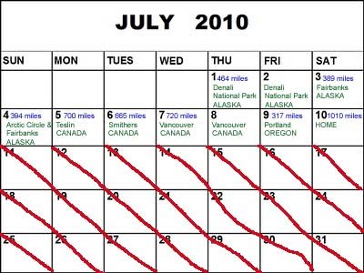
After a speedy oil change in Medford, OR, it was 735 miles of the 5-freeway. Obviously the drive was uneventful, except dealing with the horrible smell of the cow "factories" at regular intervals along the freeway. We made it home around midnight. Although we are so sad that our trip has come to an end, we are so happy to be home. We have a new appreciation for our own bed, an easily accessible bathroom, healthy food, and all of the other comforts of home. THANK YOU to everyone who kept track of us and our trip by reading the blog, and thanks especially to our commenters! The only thing that we have left to post is more photos from our trip via Snapfish, which we'll take our time doing, starting with our kayaking adventure and through to the end of the trip.
Wednesday, July 14, 2010
Drive Home: July 10
Drive to Medford, OR: July 9
 Two hour wait at the Vancouver border, loads of construction (freeway down to a single lane many times), rush hour traffic, and several broken down cars and accidents blocking lanes: these things sum up our day of driving. We had over 15 hours in the car thanks to these complications, but somehow we made it to Medford around 1:00am. Of course, just before we arrived the "maintenance required" light came on once again - a perfect end to our day.
Thursday, July 8, 2010
Vancouver, British Columbia, Canada: July 8
 Vancouver is experiencing a record heat wave. Today reached around 88 degrees and last night it only went down to about 75 degrees (no A/C in our hostel). It probably feels warmer to us than it normally would, seeing as how we've just finished a month in very chilly weather wearing long underwear! We spent several hours walking around Granville Island (not actually an island). There's a public market with crafts and fresh food, and it's located on the waterfront. It's a haven for boaters and artists, so there were lots of unique shops. It was a beautiful day and such a great place to stop and catch our breath after so many driving days. After that we walked around the various downtown districts. We definitely got our fill of trinket shops selling Canadian flags and shirts, as well as the maple syrup vendors. Next we headed to Stanley Park where it seemed like everyone in Vancouver was walking, biking, or sunbathing at the beach. Everyone was trying to enjoy this unusually nice weather. We ended the day with a delicious veggie meal at a trendy Japanese eatery with the well thought out name of "Eatery."
Drive to Vancouver: July 7
 This was another marathon driving day, not because of how far we went but because of how gnarly the road was. Thanks to Google Maps for sending us on the steepest, narrowest, curviest road in the world - fewer miles than the alternate route, which we later discovered was on a smooth, paved, straight parkway! Our speed never topped 35 mph and the thermometer read 98 degrees for a large part of the day.
Tuesday, July 6, 2010
Drive to Hyder & Prince George (Part 2)
 We continued along the bumpy dirt road for about 25 more miles as it crisscrossed between the US and Canadian border. Our destination was Salmon Glacier, North America's 5th largest glacier. Eventually the road led us up a ridge to a scenic overlook that offered sweeping 180 degree views from high above the glacier. In the afternoon we drove to Prince George, British Columbia - 500 miles, 8 hours. We saw a chubby Hoary Marmot crossing the road (but we weren't able to get a photo because he was surprisingly quick on his feet) and a young caribou feeding by the side of the road. It's amazing how much driving Gabe has done...he actually has developed blisters on his fingers from gripping the steering wheel for so many hours. He's definitely been in "the zone" every day while Jenny has provided the entertainment (although she has offered to take over driving many times!). SIDE NOTE - Today we were lucky enough to drive past: the world's largest fly fishing pole, the "best place on earth to stay," the geographic center of British Columbia, the "world's best pizza," and many, many "gateway to..." towns. It seems that in Canada every single town has to have some claim to fame, and sometimes it's a real stretch! ANOTHER SIDE NOTE - Today the temperature hit 80 degrees for the first time since Utah (day 2 of our trip). This was a reminder to us that it's July and not January!
Drive to Hyder, Alaska & Prince George, BC (Part 1): July 6
 Over the past few days we've driven so far south that we finally got our first night of real darkness in almost a month last night when we stayed in Stewart, British Columbia, which is just across the border from the town of Hyder, Alaska. Hyder, population 100, is a very unique place. It's situated on a tiny tip of land, surrounded by water and steep mountains on all sides. The only way to reach Hyder is via an extremely remote gravel road through the middle of British Columbia. The closest US town by road, Skagway, Alaska, is located over 1,000 miles away. As a result of its isolation from the rest of the US and its dependence on the Canadian border town of Stewart, Hyder is a very special town: the residents use Canadian currency, they set their clocks to Canadian time, and they send their children to Canadian schools. Each time they need to get groceries or go to the bank, Hyder residents have to pass through Canadian customs and immigration. Our first activity today was to travel just outside of town to the Fish Creek bear viewing area. Since the salmon aren't yet running our expectations were low. Later, the Ranger mentioned that several people had been waiting for days to catch a glimpse of a bear. However, within seconds of our arrival a big grizzly came ambling along down the middle of the creek, not more than 20 feet from the viewing platform, munching on nearby shrubs and checking for fish. This is the first time we've seen a bear in this type of habitat.
Monday, July 5, 2010


Drive to Stewart, British Columbia, Canada: July 5
 We decided to exit the Alaska-Canada Highway early and take a detour on our way home on the Cassiar Highway south through the middle of British Columbia. Although this route is shorter in distance it takes quite a bit longer due to the rough road conditions, but it also offers superior scenery and wildlife viewing opportunities. It did not disappoint!! Our first run-=in was with some Stone Sheep, seemingly munching on gravel by the side of the road. They didn't seem to be bothered at all by our presence and went about their business as we stopped to take a few photos. The next encounter was with a very cute and curious red fox. First he circled our car to check us out and pose for a few photos. Then he sauntered down the street behind us and kept turning back to check on us every few paces. He looked pretty scraggly. Maybe he was hoping for a free meal. At this point in our drive we were feeling very content with the wildlife we had seen. We got to check off two new animals from our list, but we weren't done yet...Gabe's eagle-eye spotted a black bear (colored light brown) hanging out on the side of the road. When we pulled up close he walked over to a tree, stretched up, and put his paws on it and looked over and stared at us. That made for a very cool photo. During the last half-hour of our 12 hour journey (657 miles), we saw 4 additional black bears. Each one was eating grass beside the road and after making eye contact with us they went back to eating their dinner. However, the last bear experience was a bit different and more exciting. We pulled the car up alongside where the bear was eating and Jenny popped out of the sunroof to get some photos. The bear meandered over to the side of the car, and at one point was less than a foot away from the passenger door, just below where Jenny was!! Luckily, it wasn't acting aggressive so we just let him check us out and then he went on his way, crossing the street just behind our car. We expected to see animals, but this drive was a wildlife wonderland!!
Sunday, July 4, 2010
Drive to Whitehorse, Yukon Territory, Canada: July 4
 Happy 4th of July! If you're tracking our progress, you may have figured out that our plans changed slightly. We decided to push to the Arctic Circle and Fairbanks in one day instead of 2 so that we could shorten our driving time each day thereafter. Today was an uneventful 602 miles (13 hours) of driving to Whitehorse. We spotted one coyote and one moose along the way. Time to rest for another long driving day tomorrow - we're going to try to make it to Stewart, British Columbia, Canada. The next day we'll go to Prince George, BC, and then to Vancouver the following day where we're giving ourselves a full day to recuperate. We're cutting out Portland and will instead drive to Medford, OR so that we can avoid driving over 1,000 miles on our last day. I guess we've become more realistic as our trip has progressed!!
Drive to Arctic Circle and Fairbanks: July 3
 It took us 14 hours to drive only 540.4 miles, so you can imagine the road conditions going up to the Arctic Circle! We had to contend with an obstacle course of muddy, rocky, gravely roads and hell-on-wheels big rigs. Ironically, this was perhaps our warmest day of the trip at a boiling 75 degrees! The Arctic Circle marks the point at which the sun does not set on the summer solstice. Once we had arrived, we were the furthest distance from home that we will be on this trip - a symbolic turnaround point: the beginning of our long drive home. Knowing what a grueling driving day this would be (and each day after until we reach home), we had made reservations months ago at a hostel in Fairbanks for a private room to ensure a good night's sleep. When we arrive there at 9pm (check-in was until 10pm), bleary-eyed and exhausted from our long haul, we were casually informed that our room - the ONLY private one - had been given away a half-hour earlier. However, we were told that we were in luck - they had 2 remaining beds available in the mixed-gender dorm room! After our 14-hour drive, we suspected that the frat-house atmosphere of the dorm room would not be conducive to a good night's sleep. We now have a profound appreciation for the comforts of Best Western, where we chose to spend the night rather than at the hostel (and the only place that still had a room available that late on a Saturday night the day before a holiday). The next morning we were pleasantly surprised to receive an apology from the hostel owner along with $100 to pay for the difference in cost of the hostel and Best Western. That being said, we still would not recommend GoNorth Hostel for anyone planning to travel to Fairbanks, Alaska!
Drive to & Camping in Denali NP: July 1-2
 July 1st: We drove 423 miles from Kenai to Denali National Park. A black bear ran out into the road in front of us, but he turned around and ran back into the woods and we were able to stop in time. We saw two moose (husband and wife?) feeding on the side of the road as we entered the park around 10pm. We tried to go to sleep with the bright sun shining into our tent at midnight!
July 2nd: We started the day with only a couple of hours of sleep - got on the 6am bus tour of the park. Denali National Park doesn't allow private vehicles into the park past mile 14 - Savage River - where we were camping. The bus goes 4.5 hours through tundra and mountains to a remote visitor's center. You can hop off the bus at any point and catch another one passing by when you're ready. We got on and off several times to go hiking and saw moose, bears, two wolf packs, coyote, caribou, and sheep (all wildlife sightings were from the bus). On the way back to the campsite a lazy porcupine meandered across the road in front of us. WOW - a first for us and something new to cross off our list!
July 1st: We drove 423 miles from Kenai to Denali National Park. A black bear ran out into the road in front of us, but he turned around and ran back into the woods and we were able to stop in time. We saw two moose (husband and wife?) feeding on the side of the road as we entered the park around 10pm. We tried to go to sleep with the bright sun shining into our tent at midnight!
July 2nd: We started the day with only a couple of hours of sleep - got on the 6am bus tour of the park. Denali National Park doesn't allow private vehicles into the park past mile 14 - Savage River - where we were camping. The bus goes 4.5 hours through tundra and mountains to a remote visitor's center. You can hop off the bus at any point and catch another one passing by when you're ready. We got on and off several times to go hiking and saw moose, bears, two wolf packs, coyote, caribou, and sheep (all wildlife sightings were from the bus). On the way back to the campsite a lazy porcupine meandered across the road in front of us. WOW - a first for us and something new to cross off our list!
Bear Viewing Part 2: June 30
 We also watched a mom with very young triplet cubs for about an hour, eating grass, playing, and napping about 30 feet from us (see photo above). We also saw three juveniles roughhousing nearby. After watching them play-wrestling for several minutes, we trekked into the forest toward another bear viewing area. Along the way we were taken by surprise as the juveniles, still in play-mode (which looks awfully similar to hunting-mode!), bounded right past us. Although they were less than 20 feet away, they didn't seem to know or care about our presence. This was an amazing day!
Bear Viewing in Lake Clark NP, Alaska - Part 1: June 30
 We caught a tiny 4-seater plane from Kenai to Lake Clark National Park, across the Cook Inlet. We spent today up close and personal with bears in the Chinitna Bay. Seventy-five miles from the nearest road (only accessibly by boat or plane), our plane had to land on the pebbly beach. As we were flying in we crossed over a large meadow adjacent to the lodge where our tour began. From our vantage point above we could make out several dozen large brown bears. Some were sitting still eating grass while others were running around the meadow creating trails in the grass that appeared to us as geometric patterns. Even from several hundred feet in the air it was clear that these powerful creatures could run with authority far faster than any human. Upon landing we were met by our "grizzled" bear guide. We knew he meant business when he pulled up in a beat-up truck with a bullet hole in the windshield, a massive handgun strapped to his side, and a loaded shotgun sitting in his passenger seat. Fire power was a necessity as there were over a hundred gigantic brown bears within a mile radius of where we landed. In fact, only minutes earlier one had wandered along the stretch of sand where we were standing. Over the course of the next 7 hours we were lucky enough to witness dozens of bears up close in their natural habitat. This included a mom and two cubs digging for clams just off-shore from where we were situated on the beach (see photo above).
Kenai Fjords NP & Drive to Kenai, Alaska: June 29
 Rain greeted us on our last day in Seward. Luckily we were inside a boat for the day, so we were able to keep relatively dry. We took a day-long tour along the coastline of Kenai Fjords National Park where we saw lots of wildlife. Right off the bat a bunch of fin whales made an appearance, which the captain said was very rare. How lucky! Maybe they knew we still needed to check them off of our list of wildlife viewed! We also passed a pod of humpback whales, sea otters (playing, of course), puffins, and Dall's porpoises that followed our wake. The Aialik Glacier was our final destination. It was a majestic blue and larger than any glaciers we had previously seen. It was also active, so we saw it calve multiple times during our visit. We had another double-header today, having to drive 3 hours to the city of Kenai. We went to bed immediately, knowing that our day would begin at the crack of dawn the next day. Oh wait - there is no dawn when the sun barely goes down!
Seward, Alaska: June 28
 We awoke to bright sun shining through our tent. As many of you may know, we aren't experienced kayakers, but we decided to include one paddling adventure because we heard it was a good way to see the coastline and wildlife. We were in a double kayak, Jenny in front as head-paddler and Gabe in back as lead-steerer. The trip was an all-day affair through Resurrection Bay, 6 miles up and back. In preparation for the trip, we had to don "splash skirts," huge rubber overall/skirt combo - they really came in handy when the wind and waves picked up, preventing water from drenching us. Our route hugged the coastline up the bay where we spotted several bald eagles. At our turnaround point we beached the kayaks in a small pebbly cove. We got re-energized with a picnic on the beach IN THE SUN - a rarity in these parts! Our guide led us on a hike through rainforest out to another cove that was used as a gun station during WWII. On the way back our arms were definitely feeling sore - we discovered new muscles in our upper bodies! A few sea otters came very close to the kayaks and peeked their heads up to say hello. Although we were exhausted at the end of the day, there was still more to see and do! We headed over to a dog sled camp run by a former Ididarod champion. This is an 1,150 mile, 10-17 day race between Anchorage and Nome. In fourth grade students read several stories that take place in Alaska, and one in particular about the Ididarod, so it was especially cool for Jenny to see this dog sled camp in person. We toured the kennel and met the dogs, who are all competitive sled dogs (prepping for the winter races) and who couldn't wit to get hooked up to the sled. We sat on a wheeled sled and were pulled along a forest trail. Then a musher, someone who drives the sled, showed us a real sled and all of the gear that she takes along on a race. Lastly we met the newborn puppies that would soon begin their training. We came away with mixed feelings about the sport - the dogs were obviously well cared for and loved, but they were kept in cramped quarters and the idea of them spending their lives hooked to a sled was disturbing.
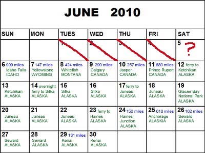
Sunday, June 27, 2010
Seward, 6\27 (31 photos), by Jennifer Bowne
I'd like to share my Snapfish photos with you. Once you have checked out my photos you can order prints and upload your own photos to share.
Click here to view photos

drive to Seward, 06\26\2010 (8 photos), by Jennifer Bowne
I'd like to share my Snapfish photos with you. Once you have checked out my photos you can order prints and upload your own photos to share.
Click here to view photos

Seward; June 27
 We woke to a light rain, but that didn’t stop us from our activity for the day: a long, steep hike up to Exit Glacier and a trek across the glacier. It was a 2-mile hike up, but with a 1500-foot elevation gain, and we had to contend with steep, muddy, rocky, slippery terrain and it felt like we were on a Stairmaster for 1 1/2 hours straight! When we reached the edge of the glacier we had to put on helmets and attach crampons to our hiking boots to prepare for our trek across the ice. Relative to our previous glacier trek, on the Exit Glacier we covered much more ground, blazing a trail a couple miles across and around the glacier. Our position on the glacier afforded sweeping views of the mountains and valley below. After a couple of hours on the glacier we hiked back down and then took a well-deserved break the rest of the afternoon to do our laundry.
Drive to Seward; June 26
 After having spent the night at a hostel in Anchorage, we provisioned ourselves and hit the road for the 150-mile drive to Seward, which is on the Kenai Peninsula south of Anchorage. We drove along the Cook Inlet, so the views were spectacular and we past several glaciers on the way. The road wound along the inlet with the ocean on our right and steep cliffs going up on our left. These cliffs are home to Dall sheep, so our eyes were peeled and we finally spotted one lone sheep munching on flowers on the cliff face, only about 50-feet above the highway. We made two stops along the way: Portage Glacier, which has receded so much that you can't actually see it from the Visitor's Center (but you can from other vantage points); and the small town of Hope. Lonely Planet describes Hope as one of the last cute little towns in Alaska without a touristy gift shop. Hope first came to being nearly 100 years ago after a very minor gold strike and it seems there has been little or no development since that time. There were a couple of restaurants, an art gallery (in the artist's house), and a handful of homes all in slightly rehabilitated ramshackle old buildings. It started to rain in the afternoon, just in time for us to camp!
Friday, June 25, 2010
drive to Anchorage: 6\25 (10 photos), by Jennifer Bowne
I'd like to share my Snapfish photos with you. Once you have checked out my photos you can order prints and upload your own photos to share.
Click here to view photos

Drive to Anchorage, Alaska: June 25
 "On the road again. Just can't wait to get on the road again..." - This song does NOT apply to us! However, even though today was one of our really long driving days it seemed to go by pretty quickly. We logged close to 700 miles, hitting the road this morning at 5am. We gained an hour crossing back into the US (easy, once again), but even so we didn't arrive in Anchorage until after 7pm. Along the way we stopped at Matanuska Glacier, which is the most easily accessible glacier in Alaska. We were able to reach the terminus by driving off the main road for a few miles and then hiking 15 minutes to the where the ice began. At one point we took a wrong turn and ended up walking on sinking mud/ice that had been under the glacier not too long ago. Once we realized that we were not on the path anymore, we met up again with the trail and finally reached the glacier. About 30 miles before Anchorage we stopped in a cute town called Palmer. For those of you who have never heard of Palmer, it's world renowned (except most people in the world haven't heard of it!) for its 1000+ pound pumpkins, 67-pound celery, and 100-pound cabbages which are products of very fertile soil and 20+ hours of sunlight during the growing season. Tonight there was a small craft fair happening just as we drove through, so we had an opportunity to see the creations of several local artists.
drive to Haines Junction: 6\24 (8 photos), by Jennifer Bowne
I'd like to share my Snapfish photos with you. Once you have checked out my photos you can order prints and upload your own photos to share.
Click here to view photos

Meals
 Many of you have wondered what we eat every day. Usually, we begin with a yogurt, some fruit (bananas, apples, or grapes), and a granola bar. For lunch we usually made sandwiches of soy meat and cheese or peanut butter and honey. We've been able to find pretty good fruits and vegetables at local grocery stores. Then we either force down another sandwich for dinner or have a quick meal at a local, cheap eatery. This is one way we've found to keep our expenses WAY down on this trip, along with camping. Pictured above is one of our more gourmet meals...last night we had a kitchen in the cabin so we made delicious spaghetti and washed it down with an ice-cold root beer. This was a real treat, as you can see from the photo above!
Haines, AK to Haines Junction, Yukon, Canada: June 24
 As usual, today we had absolutely no trouble as we passed through the Canadian border. We've heard many horror stories, especially pertaining to transporting bear spray, but we've just told the customs agent and they haven't given us any problems. Within minutes of crossing into Canada, we spotted a black bear having breakfast of fresh berries, twigs and roots by the side of the road. As we snapped several photos, he didn't seem to mind. Eventually we had to continue our drive, but we could have watched him all day. In Haines Junction we stayed in a cute cabin where we were actually HOT - that's a first in Alaska!
Thursday, June 24, 2010
Ferry to Haines, Alaska: June 23
 The pouring rain returned last night and this morning we revisited the delightful experience of taking apart our tent and closing down camp in the middle of a driving rain storm. After packing up, we had to take our car in for an oil change…luckily that fixed the “maintenance required” light problem! This is the first time we’ve required two oil changes in less than three weeks, but we have logged over 3,500 miles already, with many more to come. Then we took advantage of our last day in the “big city” by doing some grocery shopping to provision ourselves for more remote destinations. Our next stop is Haines after a 4 1/2 hour ferry ride, which is the last for this trip. Hopefully it will be long enough for our camping gear to dry out a bit. **It’s later tonight and we’ve decided that rather than camping in the pouring rain with camping gear that never dried out from last night, we would instead stay at The Halsingland Hotel (see photo above), which occupies several buildings in historical Fort Seward in Haines. This fort was the US government’s first military establishment in Alaska, built at the turn of the last century. When we called for rates, desperate to treat ourselves to a real bed out of the rain, their quote was ridiculously high. However, when we checked Orbitz on Jenny’s iphone we got an outstanding rate that wasn’t too much more than camping (a little plug for Orbitz and for the iphone!) – at least that’s how we rationalized treating ourselves to the room tonight! The proprietor was super friendly and upgraded us to a huge room with a private bathroom in the old Officers’ Quarters – we must have looked very worn out when we arrived to get such special treatment! Tomorrow we’ll be heading into Canada for one night in Haines Junction, and then we’ll cross back into Alaska again the following day. We’ll post again when we have time and internet.
Juneau, 6\22\2010 (38 photos), by Jennifer Bowne
I'd like to share my Snapfish photos with you. Once you have checked out my photos you can order prints and upload your own photos to share.
Click here to view photos

Wednesday, June 23, 2010
Tracy Arm Fjord, Juneau: 6/22
 Surprise…we got rain today! Thankfully, our boat tour to Tracy Arm Fjord to view glaciers took us far enough away that it was cloudy yet dry. We were told that glaciers and icebergs are the most beautiful blue when there’s cloud cover, although we can’t say we were glad that it wasn’t sunny! For those of you who haven’t heard of a fjord, it’s a narrow glacier-carved valley filled with sea water. Tracy Arm Fjord is 50 miles south of Juneau and known as one of the most dramatic fjords in Alaska because of its steep walls and narrow channel, which at points is only 1/2 mile wide with 5,000-7,000 ft. mountains rising on either side. It also has two beautiful glaciers which were quite a bit different from those we saw in Glacier Bay National Park. This was an all-day tour and it took us 2 1/2 hours to reach the fjord. Along the way we were visited by many harbor seals and pups…right now is the calving season so there were lots of babies around. During this season, to escape the killer whales the seals have to move close to the ice-clogged waters adjacent to the glaciers. We were told that both of the glaciers on the tour were very active, calving (dropping ice into the water) often, so the narrow channel was wall-to-wall icebergs. However, since we were on a small boat with an experienced and daring captain, we were able to slowly negotiate the ice to get up very close to the glaciers. At each of the glaciers the captain cut the engine and we would watch and wait for the calving. We were hoping to be lucky enough to see “the big one.” In California, that means a big earthquake, but here in Alaska that refers to a huge calving of a glacier. After much patience and false starts, we were rewarded with a spectacular show at both glaciers. The calving produced a cracking bang, reminiscent of a gun shot, but by the time we heard the bang it was usually too late to see the ice falling due to the relative slowness of sound waves. When some of the larger chunks of ice splashed into the water, sizable waves were sent in our direction. On the way home our captain spotted a large black bear on the shoreline and took us in for a very close look. We had to stay completely silent so as not to disturb him. The bear was foraging for mussels, barnacles, and kelp, which seems to be their diet before the berries and salmon come in. The captain cut the engine and let us observe the bear for 15 minutes and we were so close that at several points he seemed to catch a whiff of our scent and shot us a curious (or hungry?) glance.
Tuesday, June 22, 2010
Juneau, 6\21\2010 (33 photos), by Jennifer Bowne
I'd like to share my Snapfish photos with you. Once you have checked out my photos you can order prints and upload your own photos to share.
Click here to view photos

Mendenhall Glacier Trek, Juneau, 6/21
 Happy Summer Solstice! In Juneau that means over 19 hours of sunlight. Each day seems to top all of the others and leaves us with the feeling that it can't get any better. Today was no exception! We began our day with a helicopter ride to the top of Mendenhall Glacier where a guide led us on a trek across the glacier. We only had three people total in our group, so it felt like a private excursion. We learned how to use an ice pick to climb an ice wall and how to safely cross the glacier with crampons. Because our group was so small, the guide decided to take us up to an area where no other group has gone, which required using a pulley system and rope to climb up a sheer wall of ice that was 50 feet high. Later we repelled down that same wall. The landscape of the glacier was different than we had imagined...it looked like a totally different world, full of sharp, spiked peaks of ice and clear-blue water that we could walk on! This was by far our most exciting experience!
Juneau, 6\20\2010 (30 photos), by Jennifer Bowne
I'd like to share my Snapfish photos with you. Once you have checked out my photos you can order prints and upload your own photos to share.
Click here to view photos

Monday, June 21, 2010
Whale Watching, Juneau, 6/20
 This was the very first HOT day...what a relief! At one point we actually had to dust off the air conditioner in the car, and people were walking around in shorts and t-shirts. One girl was even in her bikini top - that might have been taking it too far! The highlight of the day was our whale-watching trip with "Captain Larry," an old, crusty, salty seaman who has been doing whale-watching tours in Juneau longer than anyone has been alive (actually, just longer than any other tour company!). He was able to spot whales from miles away without using binoculars, and we were the first boat on the scene. Maybe he had sonar? At the outset, Captain Larry said that they don't see Orca (i.e. Killer) Whales 90% of the time. However, within minutes of leaving the dock we spotted a sizable pod of them! Captain Larry used his expertise to get just close enough to the whales without disturbing them, which made for some National Geographic-quality photos. We then went further into the ocean and Captain Larry knew exactly where to look for humpbacks. Again, we got extremely lucky because we came upon a pod of humpbacks feeding using the "bubble" method. This is when they surround a bunch of Krill by blowing bubbles around them, and herd them toward the surface. Then they take turns shooting up from below and swim sideways with their mouths open to scoop up the Krill. The owner of the campsite where we're staying said it took her 12 years to see bubble feeding, and Captain Larry said it was extremely unusual to spot this behavior. When we got back to shore we decided that we had enough energy to return to the Mendenhall Glacier for a 4-mile hike through steep rainforest hillsides where there were spectacular vistas of the mountains and glacier. Little did we know that another first awaited us after we finished the hike. From a distance we heard some kids screaming "beaver," so we decided to investigate. They pointed out where they had seen it, and even though it required tramping through several icy-cold, glacier-fed streams WITHOUT our socks and shoes on, we made the trek...and boy did it pay off! There was a family of beavers, very busy and hard at work carrying branches to their dam and munching on bark and leaves. After the hike we still weren't completely tired out, and the sun doesn't go down until around 11pm, so we drove the only road out of town, which dead ends 40 miles outside the city. Despite the fact that the drive took us several hours and the hour was late, at this latitude the sunset lasts nearly two hours, so we had sunset ocean views nearly the entire drive.
Juneau, 6\19\2010 (26 photos), by Jennifer Bowne
I'd like to share my Snapfish photos with you. Once you have checked out my photos you can order prints and upload your own photos to share.
Click here to view photos

Juneau, 6\18\2010 (12 photos), by Jennifer Bowne
I'd like to share my Snapfish photos with you. Once you have checked out my photos you can order prints and upload your own photos to share.
Click here to view photos

Glacier Bay National Park, Juneau, 6/19
 The day started at 4:45am (and we're an hour behind Pacific Coast time right now) when we boarded a 4-seater prop plane. We were the only passengers on the magnificent flight over the Chilkat Mountains. At times we were so close to the mountain tops that you could spot individual wildflowers. We landed in Gustavis, a tiny town on the edge of the national park, and took an all-day boat tour through Glacier Bay. Our final destination was Margerie Glacier and Grand Pacific Glacier (only 3/4 mi. from the Canadian border). However, along the way we spotted lots of wildlife. There were tons of sea otters playing in the water when we first began our ride (this was a first for us). Then we saw humpback whales, porpoises, and sea lions. As we got further into the bay, we passed a rocky hillside with several mountain goats and a couple of kids (another first...and Jenny was the eagle eye who spotted them first!). On several occasions we also observed groups of tufted puffins (ANOTHER first), which are small black birds with colorful, tucan-like beaks. Later we were told to keep a lookout for bears along a certain beach, and guess who spotted one...that's right, old eagle eye Jenny! It was a sole grizzly foraging along the waterline for mussels. We were so close that we could see him lifting up rocks in search for food. After several hours on the water we finally reached our first iceburgs and glaciers. We learned that mini-iceburgs are called "burgie bits" and "growlers." The Margerie Glacier was a towering pale blue wall of ice stretching a mile along the waterline. You could see the scrap marks that chronicled its journey down from the Brady Icefield. We saw it calve (pieces of ice break off into the water), along with many waterfalls as ice was beginning to melt. On the way back, we saw several other glaciers, including: Grand Pacific, John Hopkins, Reid, and Lampugh...all were stunning! We flew back to Juneau on another tiny plane that evening, and we were so exhausted that we fell asleep quickly that night!
Mt. Roberts, Juneau, 6/18
 Today was our first rain-less day in what seemed like several weeks!! We decided to hit the trails and do the 5-mile Mt. Roberts hike. We started by taking a tram up to the top of the mountain. When we arrived, we hiked above the treeline into the sub-alpine region to gain spectacular views of the area. Then we hiked down the mountain through lush rainforest. The hike was pretty grueling, as there was much mud from the previous rainy weather, but it was a great workout and well worth it once we made it to the bottom! Later in the afternoon we decided to drive around Douglas Island, which is opposite Juneau and connected by a bridge. We stopped at several turnouts for great views and ended up hiking along a beach where had mountain views and saw various seabirds.
Sitka & Juneau, 6\17\2010 (5 photos), by Jennifer Bowne
I'd like to share my Snapfish photos with you. Once you have checked out my photos you can order prints and upload your own photos to share.
Click here to view photos