Sunday, June 27, 2010

Seward, 6\27 (31 photos), by Jennifer Bowne


I'd like to share my Snapfish photos with you. Once you have checked out my photos you can order prints and upload your own photos to share.
Click here to view photos

drive to Seward, 06\26\2010 (8 photos), by Jennifer Bowne


I'd like to share my Snapfish photos with you. Once you have checked out my photos you can order prints and upload your own photos to share.
Click here to view photos

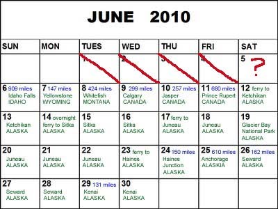
Seward; June 27

We woke to a light rain, but that didn’t stop us from our activity for the day: a long, steep hike up to Exit Glacier and a trek across the glacier. It was a 2-mile hike up, but with a 1500-foot elevation gain, and we had to contend with steep, muddy, rocky, slippery terrain and it felt like we were on a Stairmaster for 1 1/2 hours straight! When we reached the edge of the glacier we had to put on helmets and attach crampons to our hiking boots to prepare for our trek across the ice. Relative to our previous glacier trek, on the Exit Glacier we covered much more ground, blazing a trail a couple miles across and around the glacier. Our position on the glacier afforded sweeping views of the mountains and valley below. After a couple of hours on the glacier we hiked back down and then took a well-deserved break the rest of the afternoon to do our laundry.

Drive to Seward; June 26

After having spent the night at a hostel in Anchorage, we provisioned ourselves and hit the road for the 150-mile drive to Seward, which is on the Kenai Peninsula south of Anchorage. We drove along the Cook Inlet, so the views were spectacular and we past several glaciers on the way. The road wound along the inlet with the ocean on our right and steep cliffs going up on our left. These cliffs are home to Dall sheep, so our eyes were peeled and we finally spotted one lone sheep munching on flowers on the cliff face, only about 50-feet above the highway. We made two stops along the way: Portage Glacier, which has receded so much that you can't actually see it from the Visitor's Center (but you can from other vantage points); and the small town of Hope. Lonely Planet describes Hope as one of the last cute little towns in Alaska without a touristy gift shop. Hope first came to being nearly 100 years ago after a very minor gold strike and it seems there has been little or no development since that time. There were a couple of restaurants, an art gallery (in the artist's house), and a handful of homes all in slightly rehabilitated ramshackle old buildings. It started to rain in the afternoon, just in time for us to camp!

Friday, June 25, 2010

drive to Anchorage: 6\25 (10 photos), by Jennifer Bowne


I'd like to share my Snapfish photos with you. Once you have checked out my photos you can order prints and upload your own photos to share.
Click here to view photos

Drive to Anchorage, Alaska: June 25

"On the road again. Just can't wait to get on the road again..." - This song does NOT apply to us! However, even though today was one of our really long driving days it seemed to go by pretty quickly. We logged close to 700 miles, hitting the road this morning at 5am. We gained an hour crossing back into the US (easy, once again), but even so we didn't arrive in Anchorage until after 7pm. Along the way we stopped at Matanuska Glacier, which is the most easily accessible glacier in Alaska. We were able to reach the terminus by driving off the main road for a few miles and then hiking 15 minutes to the where the ice began. At one point we took a wrong turn and ended up walking on sinking mud/ice that had been under the glacier not too long ago. Once we realized that we were not on the path anymore, we met up again with the trail and finally reached the glacier. About 30 miles before Anchorage we stopped in a cute town called Palmer. For those of you who have never heard of Palmer, it's world renowned (except most people in the world haven't heard of it!) for its 1000+ pound pumpkins, 67-pound celery, and 100-pound cabbages which are products of very fertile soil and 20+ hours of sunlight during the growing season. Tonight there was a small craft fair happening just as we drove through, so we had an opportunity to see the creations of several local artists.

drive to Haines Junction: 6\24 (8 photos), by Jennifer Bowne


I'd like to share my Snapfish photos with you. Once you have checked out my photos you can order prints and upload your own photos to share.
Click here to view photos

Meals

Many of you have wondered what we eat every day. Usually, we begin with a yogurt, some fruit (bananas, apples, or grapes), and a granola bar. For lunch we usually made sandwiches of soy meat and cheese or peanut butter and honey. We've been able to find pretty good fruits and vegetables at local grocery stores. Then we either force down another sandwich for dinner or have a quick meal at a local, cheap eatery. This is one way we've found to keep our expenses WAY down on this trip, along with camping. Pictured above is one of our more gourmet meals...last night we had a kitchen in the cabin so we made delicious spaghetti and washed it down with an ice-cold root beer. This was a real treat, as you can see from the photo above!

Haines, AK to Haines Junction, Yukon, Canada: June 24

As usual, today we had absolutely no trouble as we passed through the Canadian border. We've heard many horror stories, especially pertaining to transporting bear spray, but we've just told the customs agent and they haven't given us any problems. Within minutes of crossing into Canada, we spotted a black bear having breakfast of fresh berries, twigs and roots by the side of the road. As we snapped several photos, he didn't seem to mind. Eventually we had to continue our drive, but we could have watched him all day. In Haines Junction we stayed in a cute cabin where we were actually HOT - that's a first in Alaska!

Thursday, June 24, 2010

Ferry to Haines, Alaska: June 23

The pouring rain returned last night and this morning we revisited the delightful experience of taking apart our tent and closing down camp in the middle of a driving rain storm. After packing up, we had to take our car in for an oil change…luckily that fixed the “maintenance required” light problem! This is the first time we’ve required two oil changes in less than three weeks, but we have logged over 3,500 miles already, with many more to come. Then we took advantage of our last day in the “big city” by doing some grocery shopping to provision ourselves for more remote destinations. Our next stop is Haines after a 4 1/2 hour ferry ride, which is the last for this trip. Hopefully it will be long enough for our camping gear to dry out a bit. **It’s later tonight and we’ve decided that rather than camping in the pouring rain with camping gear that never dried out from last night, we would instead stay at The Halsingland Hotel (see photo above), which occupies several buildings in historical Fort Seward in Haines. This fort was the US government’s first military establishment in Alaska, built at the turn of the last century. When we called for rates, desperate to treat ourselves to a real bed out of the rain, their quote was ridiculously high. However, when we checked Orbitz on Jenny’s iphone we got an outstanding rate that wasn’t too much more than camping (a little plug for Orbitz and for the iphone!) – at least that’s how we rationalized treating ourselves to the room tonight! The proprietor was super friendly and upgraded us to a huge room with a private bathroom in the old Officers’ Quarters – we must have looked very worn out when we arrived to get such special treatment! Tomorrow we’ll be heading into Canada for one night in Haines Junction, and then we’ll cross back into Alaska again the following day. We’ll post again when we have time and internet.

Juneau, 6\22\2010 (38 photos), by Jennifer Bowne


I'd like to share my Snapfish photos with you. Once you have checked out my photos you can order prints and upload your own photos to share.
Click here to view photos

Wednesday, June 23, 2010

Tracy Arm Fjord, Juneau: 6/22

Surprise…we got rain today! Thankfully, our boat tour to Tracy Arm Fjord to view glaciers took us far enough away that it was cloudy yet dry. We were told that glaciers and icebergs are the most beautiful blue when there’s cloud cover, although we can’t say we were glad that it wasn’t sunny! For those of you who haven’t heard of a fjord, it’s a narrow glacier-carved valley filled with sea water. Tracy Arm Fjord is 50 miles south of Juneau and known as one of the most dramatic fjords in Alaska because of its steep walls and narrow channel, which at points is only 1/2 mile wide with 5,000-7,000 ft. mountains rising on either side. It also has two beautiful glaciers which were quite a bit different from those we saw in Glacier Bay National Park. This was an all-day tour and it took us 2 1/2 hours to reach the fjord. Along the way we were visited by many harbor seals and pups…right now is the calving season so there were lots of babies around. During this season, to escape the killer whales the seals have to move close to the ice-clogged waters adjacent to the glaciers. We were told that both of the glaciers on the tour were very active, calving (dropping ice into the water) often, so the narrow channel was wall-to-wall icebergs. However, since we were on a small boat with an experienced and daring captain, we were able to slowly negotiate the ice to get up very close to the glaciers. At each of the glaciers the captain cut the engine and we would watch and wait for the calving. We were hoping to be lucky enough to see “the big one.” In California, that means a big earthquake, but here in Alaska that refers to a huge calving of a glacier. After much patience and false starts, we were rewarded with a spectacular show at both glaciers. The calving produced a cracking bang, reminiscent of a gun shot, but by the time we heard the bang it was usually too late to see the ice falling due to the relative slowness of sound waves. When some of the larger chunks of ice splashed into the water, sizable waves were sent in our direction. On the way home our captain spotted a large black bear on the shoreline and took us in for a very close look. We had to stay completely silent so as not to disturb him. The bear was foraging for mussels, barnacles, and kelp, which seems to be their diet before the berries and salmon come in. The captain cut the engine and let us observe the bear for 15 minutes and we were so close that at several points he seemed to catch a whiff of our scent and shot us a curious (or hungry?) glance.

Tuesday, June 22, 2010

Juneau, 6\21\2010 (33 photos), by Jennifer Bowne


I'd like to share my Snapfish photos with you. Once you have checked out my photos you can order prints and upload your own photos to share.
Click here to view photos

Mendenhall Glacier Trek, Juneau, 6/21

Happy Summer Solstice! In Juneau that means over 19 hours of sunlight. Each day seems to top all of the others and leaves us with the feeling that it can't get any better. Today was no exception! We began our day with a helicopter ride to the top of Mendenhall Glacier where a guide led us on a trek across the glacier. We only had three people total in our group, so it felt like a private excursion. We learned how to use an ice pick to climb an ice wall and how to safely cross the glacier with crampons. Because our group was so small, the guide decided to take us up to an area where no other group has gone, which required using a pulley system and rope to climb up a sheer wall of ice that was 50 feet high. Later we repelled down that same wall. The landscape of the glacier was different than we had imagined...it looked like a totally different world, full of sharp, spiked peaks of ice and clear-blue water that we could walk on! This was by far our most exciting experience!

Juneau, 6\20\2010 (30 photos), by Jennifer Bowne


I'd like to share my Snapfish photos with you. Once you have checked out my photos you can order prints and upload your own photos to share.
Click here to view photos

Monday, June 21, 2010

Whale Watching, Juneau, 6/20

This was the very first HOT day...what a relief! At one point we actually had to dust off the air conditioner in the car, and people were walking around in shorts and t-shirts. One girl was even in her bikini top - that might have been taking it too far! The highlight of the day was our whale-watching trip with "Captain Larry," an old, crusty, salty seaman who has been doing whale-watching tours in Juneau longer than anyone has been alive (actually, just longer than any other tour company!). He was able to spot whales from miles away without using binoculars, and we were the first boat on the scene. Maybe he had sonar? At the outset, Captain Larry said that they don't see Orca (i.e. Killer) Whales 90% of the time. However, within minutes of leaving the dock we spotted a sizable pod of them! Captain Larry used his expertise to get just close enough to the whales without disturbing them, which made for some National Geographic-quality photos. We then went further into the ocean and Captain Larry knew exactly where to look for humpbacks. Again, we got extremely lucky because we came upon a pod of humpbacks feeding using the "bubble" method. This is when they surround a bunch of Krill by blowing bubbles around them, and herd them toward the surface. Then they take turns shooting up from below and swim sideways with their mouths open to scoop up the Krill. The owner of the campsite where we're staying said it took her 12 years to see bubble feeding, and Captain Larry said it was extremely unusual to spot this behavior. When we got back to shore we decided that we had enough energy to return to the Mendenhall Glacier for a 4-mile hike through steep rainforest hillsides where there were spectacular vistas of the mountains and glacier. Little did we know that another first awaited us after we finished the hike. From a distance we heard some kids screaming "beaver," so we decided to investigate. They pointed out where they had seen it, and even though it required tramping through several icy-cold, glacier-fed streams WITHOUT our socks and shoes on, we made the trek...and boy did it pay off! There was a family of beavers, very busy and hard at work carrying branches to their dam and munching on bark and leaves. After the hike we still weren't completely tired out, and the sun doesn't go down until around 11pm, so we drove the only road out of town, which dead ends 40 miles outside the city. Despite the fact that the drive took us several hours and the hour was late, at this latitude the sunset lasts nearly two hours, so we had sunset ocean views nearly the entire drive.

Juneau, 6\19\2010 (26 photos), by Jennifer Bowne


I'd like to share my Snapfish photos with you. Once you have checked out my photos you can order prints and upload your own photos to share.
Click here to view photos

Juneau, 6\18\2010 (12 photos), by Jennifer Bowne


I'd like to share my Snapfish photos with you. Once you have checked out my photos you can order prints and upload your own photos to share.
Click here to view photos

Glacier Bay National Park, Juneau, 6/19

The day started at 4:45am (and we're an hour behind Pacific Coast time right now) when we boarded a 4-seater prop plane. We were the only passengers on the magnificent flight over the Chilkat Mountains. At times we were so close to the mountain tops that you could spot individual wildflowers. We landed in Gustavis, a tiny town on the edge of the national park, and took an all-day boat tour through Glacier Bay. Our final destination was Margerie Glacier and Grand Pacific Glacier (only 3/4 mi. from the Canadian border). However, along the way we spotted lots of wildlife. There were tons of sea otters playing in the water when we first began our ride (this was a first for us). Then we saw humpback whales, porpoises, and sea lions. As we got further into the bay, we passed a rocky hillside with several mountain goats and a couple of kids (another first...and Jenny was the eagle eye who spotted them first!). On several occasions we also observed groups of tufted puffins (ANOTHER first), which are small black birds with colorful, tucan-like beaks. Later we were told to keep a lookout for bears along a certain beach, and guess who spotted one...that's right, old eagle eye Jenny! It was a sole grizzly foraging along the waterline for mussels. We were so close that we could see him lifting up rocks in search for food. After several hours on the water we finally reached our first iceburgs and glaciers. We learned that mini-iceburgs are called "burgie bits" and "growlers." The Margerie Glacier was a towering pale blue wall of ice stretching a mile along the waterline. You could see the scrap marks that chronicled its journey down from the Brady Icefield. We saw it calve (pieces of ice break off into the water), along with many waterfalls as ice was beginning to melt. On the way back, we saw several other glaciers, including: Grand Pacific, John Hopkins, Reid, and Lampugh...all were stunning! We flew back to Juneau on another tiny plane that evening, and we were so exhausted that we fell asleep quickly that night!

Mt. Roberts, Juneau, 6/18

Today was our first rain-less day in what seemed like several weeks!! We decided to hit the trails and do the 5-mile Mt. Roberts hike. We started by taking a tram up to the top of the mountain. When we arrived, we hiked above the treeline into the sub-alpine region to gain spectacular views of the area. Then we hiked down the mountain through lush rainforest. The hike was pretty grueling, as there was much mud from the previous rainy weather, but it was a great workout and well worth it once we made it to the bottom! Later in the afternoon we decided to drive around Douglas Island, which is opposite Juneau and connected by a bridge. We stopped at several turnouts for great views and ended up hiking along a beach where had mountain views and saw various seabirds.

Sitka & Juneau, 6\17\2010 (5 photos), by Jennifer Bowne


I'd like to share my Snapfish photos with you. Once you have checked out my photos you can order prints and upload your own photos to share.
Click here to view photos

Sitka & Juneau, 6/17

On our last day in Sitka we awoke to the usual drizzle. However, this didn't stop us from taking a Ranger-guided totem pole hike through the Sitka National Historical Park. The trail took us through mist-shrouded rainforest, along spectacular coastline, and included about a dozen totem poles. At each pole the ranger explained the history and legends behind what we were seeing. At mid-day we boarded the new, fast ferry to Juneau. Midway, Jenny was christened "Sequence Champion of the World" (this is a board game introduced to us by our friends Adam & Katie that we brought along for these long ferry rides). Upon arriving in Juneau we wasted no time in seeing the sights. We took a brief walk around downtown (but it was completely deserted due to the fact that there was no cruise ship docked) and got our first glimpse of the Mendenhall Glacier, which is a large, tidewater glacier.

Wednesday, June 16, 2010

Sitka, 6\15-6\17 (24 photos), by Jennifer Bowne


I'd like to share my Snapfish photos with you. Once you have checked out my photos you can order prints and upload your own photos to share.
Click here to view photos

Sitka, Alaska: June 15-16

We arrived at 3:15am and had a much easier time setting up camp in what was only a slight drizzle. After driving to the end of the island, we found a beautiful trail to hike called "Indian River," which took us through thick, lush rain forest. In the afternoon we walked around the small downtown to view the historic sites. Sitka was the capitol of Russian America, so many of the stores sell nesting dolls and other Russian souvenirs and the town is full of buildings with Russian history and architecture. Overall, we have found Sitka much more enjoyable than Ketchikan. The houses are tidier and prettier, and it caters less to the cruise-ship crowd (i.e. fewer t-shirt and trinket shops, and more art galleries and cafes). The quality of artwork and craftsmanship is much higher here, although so are the prices to reflect this! Last night we attended the Sitka Music Festival, a concert of chamber music in the community center where the stage was backed by a 180 degree view of the Sitka Harbor and the mountains beyond. Today we began with a dance performance by a Russian dance troupe. Then we walked over to the Native Alaskan Cultural Center for a traditional Tlingit (native tribal) dance show. Next was the Raptor Center, a rehabilitation center for injured raptors, where we arrived just in time to see a bald eagle up close who had was permanently disabled and lives at the center. They are enormous, several feet high, but only weigh about 12 pounds. We walked around the grounds and observed many bald & golden eagles, ravens, owls, hawks, and other raptors recovering from various injuries, including collisions with cars and gunshot wounds. There were even several wild eagles flying around - we assuming they were visiting their friends and helping with their recovery! Tomorrow morning we'll go on a ranger-led hike around the Sitka National Historic Park, and then board the ferry to Juneau.

Ferry to Sitka, 6\14\2010 (16 photos), by Jennifer Bowne


I'd like to share my Snapfish photos with you. Once you have checked out my photos you can order prints and upload your own photos to share.
Click here to view photos

Ferry to Sitka: June 14

The journey began at 12:30am when our alarm went off inside our tent. It's amazing we even heard the alarm over the thundering roar of the rain! Have you ever tried putting away a tent, sleeping bags, and pads in the pitch dark in the middle of a downpour? We have...it's not fun! We were barely able to fit everything into the car because our stuff was in such disarray, and everything was completely soaked. We ended up jamming the dripping wet tent into the back of the car without attempting to fold it up! We had to arrive at the ferry terminal at 1:15am, but couldn't board until just before our 3:15am departure. We were pleasantly surprised to find a very comfy cabin with bunk beds and our own bathroom and shower. After drying off and sleeping for a few hours, we were rejuvenated and ready to see some of the beautiful Inside Passage (the protected coastline along Southeastern Alaska). During our 24-hour ferry ride, the sun finally came out. The scenery was gorgeous with snow-capped mountains behind blue water and green forested hills. We saw both humpback and killer whales (but we couldn't get good photos of either one), and several eagles feasting on salmon.

Ketchikan, 6\12 & 6\13 (24 photos), by Jennifer Bowne


I'd like to share my Snapfish photos with you. Once you have checked out my photos you can order prints and upload your own photos to share.
Click here to view photos

Ketchikan, Alaska: June 12-13

When we arrived on the ferry, the first place we visited was Saxman Village, a native Alaskan community of Tlingit Indians. We lucked out when we talked to a local and were invited to view an inter-tribal meeting/celebration where there was native singing and dancing. The meeting took place in what appeared to be the local high school gym and the entertainment was staged solely for the local tribe and guests without any anticipation that outsiders/tourists would attend. We slipped in through a side door after a local tribe member told us to pretend we were part of his family if anyone asked, and we just tried to lay low and blend in despite the fact that we are clearly not of native Alaskan descent and were not dressed in traditional Tlingit garb! We had a classic "are we having fun yet?" moment as we attempted to set up our tent in a driving wind and rain storm...this was after we had to shoo away a local homeless woman who had obviously set up long-term "housing" in our campsite. The night got even more interesting when, just as we were about to turn in, we discovered that our rain flap was not meant to function in the cyclone-like deluge that this Southeast Alaskan rainforest had dished out. Our sleeping bags and pads were drenched and our tent was raining from within! After somehow surviving the night, we had a respite from the rain for a few hours the next morning and took advantage of the nicer weather to go ziplining and repelling through the Tongass National Forest. For the remainder of the day we walked around downtown and enjoyed the town, despite the continuing rain, before turning in early to get a few hours sleep before waking at 1:15am to catch the ferry to Sitka.

Monday, June 14, 2010

New Blog Name!

Thanks to Caitlin for the cute blog title! We're on the 24-hour ferry to Sitka, and randomly it's the first time we've had Internet in a few days. Too bad we're too tired to post photos or details! We'll do that as soon as we have a chance to catch up on sleep.

Friday, June 11, 2010

British Columbia, Canada

Today we had our longest driving day, and Jenny drove for the first time! That's right - up to this point Gabe had done all of the driving (2,309.6 total miles)!! We drove from Jasper, Alberta to Prince Rupert, British Columbia: 697.4 miles; 14 hours of twisty, mountainous, and sometimes rainy roads. Tomorrow we finally head into Alaska. We have to be at the ferry at 5:15am and go through 3 hours of immigration, customs, and boarding for ourselves and the car. We'll arrive in Ketchikan, Alaska around 1:30pm and are hoping to spot some whales during our ferry ride. As of tomorrow we will transition from the road-trip part of our journey to the camping part, and may be without internet for several days or perhaps a week. Family: we will have our cell phones turned on, but who knows what kind of service there will be?! We'll be in touch as soon as we're able.

Icefields Parkway, Banff NP, Alberta, Canada

This is a view of a still partially frozen lake and the Rockies in the background.

drive to Prince Rupert 6\11\10 (6 photos), by Jennifer Bowne


I'd like to share my Snapfish photos with you. Once you have checked out my photos you can order prints and upload your own photos to share.
Click here to view photos

Banff & Jasper NP, 6\10\2010 (20 photos), by Jennifer Bowne


I'd like to share my Snapfish photos with you. Once you have checked out my photos you can order prints and upload your own photos to share.
Click here to view photos

Calgary to Jasper NP, Alberta, Canada - Even More Incredible Moose Sighting!

Yesterday we drove 281.1 miles...doesn't sound like much, but on windy roads it takes a very long time! We set out pretty early in order to have plenty of time to explore both Banff and Jasper National Parks. Within about a minute of entering Banff we spotted two moose right on the side of the road (see above photo...much more impressive than our previous moose sighting). We also spotted a fox running across the road - we never thought we'd get to check this off of our list of wildlife to see! We hiked out to a beautiful waterfall where we met a very friendly (and hungry) chipmunk (no, we didn't feed him). It was raining, and at one point we had hail, so our outdoor time was limited, but we spent plenty of time enjoying amazing views of the Canadian Rockies, glaciers, and lakes from the famed "Icefields Parkway."

Thursday, June 10, 2010

Calgary, Alberta, Canada (6 photos), by Jennifer Bowne


I'd like to share my Snapfish photos with you. Once you have checked out my photos you can order prints and upload your own photos to share.
Click here to view photos

Glacier National Park (12 photos), by Jennifer Bowne


I'd like to share my Snapfish photos with you. Once you have checked out my photos you can order prints and upload your own photos to share.
Click here to view photos